If you have ever driven on I-77 in SE Ohio then you may have seen a sign on the side of the road that states “Crash site of the Shenandoah”, well there are three crash site and you have to get off onto the back dirt roads to find them all, so here we go.
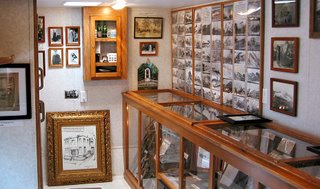
First you have to find Ava, Ohio, then drive to the south end of town or the block, it’s a very small town, look for Raynor’s Service Center then look for a trailer next to it with Shenandoah printed across the front, this is it.  If it’s not open then step inside the Service Center and ask for Bryan, the owner, he’ll be more then glad to open it up for you and tell you all about the Shenandoah, Bryan is probably the most knowledgeable person on the Shenandoah there is.
Bryan’s grandfather started this business over 75 years ago and was present when the Shenandoah crashed. We found it hard to believe how much great stuff he was able to exhibit inside the trailer, this is the best little museums that we have visited.
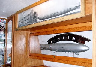
 He has many hands on exhibits which include parts of the framing that were made from duralumin, lighter then aluminum and stronger then steel, he’ll hand you a piece and tell you to try and bend it, you can’t, pieces of the outer skin of the ship which feel thinner then a sheet of paper and pieces of the bladder that held the helium, called “goldbeaters skin” it was made from the lining of an oxen’s stomach, they needed over 750,000 oxen to make all the bladders. A bladder made from stomach just doesn’t sound right. Bryan can provide you with a map and directions to all three-crash sites if you want to hunt them down and now, the story of Captain Lansdowne and the Shenandoah.
Shenandoah, an Algonquian Indian word meaning “Daughter of the Stars” was the name chosen by the Navy for America’s first lighter-then-air dirigible. Commissioned in October 1923 she was 680-feet long, 78-feet in diameter and over 93-feet tall, her 5 Packard engines produced a total of 1625 horsepower allowing her to cruise at 50 knots. Total cost 2.9 million dollars (and that’s 1923 dollars). Not only was she the first rigid airship in America she was also the first to use helium and the first to be moored to a floating mast when she tied up with the USS Patoka during maneuvers
The Shenandoah had just started a 6-day publicity tour, when early September 3 1925 she ran into a terrible thunderstorm over southeastern Ohio. The strong winds tore the ship in two causing the control car to break away and fall to the earth near Ava, Ohio (Crash site 1). The stern section continued for about another mile before crashing in Ava, Ohio (Crash site 2). The bow still afloat and being blown by the strong winds, remained aloft for another 13 miles until a farmer managed to grab one of the lines and tied it off to an oak tree near Sharon, Ohio saving the lives of the seven crew members who remained aboard. Fourteen of the 43-crew members perished in the crash, among them was the Captain, Lt Commander Zachary Lansdowne, a graduate of the Naval Academy and who was born and raised in Greenville Ohio, less then 160 miles from the crash site. Ironically this was to be Lansdowne’s last flight, he was to be transferred to sea duty immediately following the end of this flight. Lt Commander Lansdowne told the Navy that he did not want to fly this route; being raised in this area he knew about the sudden storms that could come up during September and wanted a more southerly route. The Navy insisted on the original route.
Since we’re going to be in the area for a week we thought that we would seek them out; the first site we would have never found without Bryan’s directions. It’s located on his property; he is so into the Shenandoah that he bought the property to make sure it would always be remembered. This is where the ship broke in half causing the control compartment, which hangs under the ship to break away and fall to the earth. A few people survived this fall, but Captain Lansdowne landed on a fence post and was impaled, causing his death. Site #2 is on the interstate and we’re still trying to figure out how to get to it without stopping on the interstate and climbing the fence. There is a monument in Ava to commemorate the crash and list the names of those who died; this is normal considered site #2. Site #3 is about a 20 miles drive but since we were near another item that we were looking for and Bryan had given us directions to that we will now take a little detour (or Detour through History as Cathy would say).
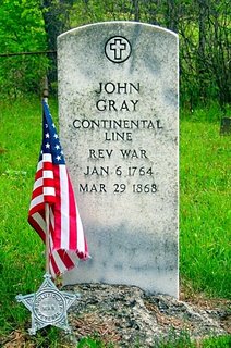
 John Gray. What? You don’t know who he is? Well John Gray was born in 1764 at George Washington’s Mt Vernon, and lived there until he was old enough to join General Washington and his father in fighting the American Revolution. John’s dad was killed in battle during the Revolution; John managed to make it through all the battles and returned to Mt Vernon where he remained friends with the first President until George’s death. His life-long friendship with the First President is pretty unique, but what John is famous for is that he was the last survivor of the American Revolution in the nation, dying on March 29, 1868 at the age of 104. Two others laid claim to being the last survivor but research done near the time of John’s death proved that he was definitely the last one. If you think about it, George Washington was referred to as the “First soldier of the revolution” and here John, who was born on George Washington’s plantation at Mt Vernon, was the “Last soldier of the revolution” History sure can be funny when you look at it in the right way.
We took all the dirt roads, managed to find the little family cemetery where John is buried and paid our respects to an American Hero.
End of the detour, Ok now we’re back on the road looking for crash site number 3. We followed all the directions that Bryan gave us and found it without any problem at all; it’s right on the side of a county road and has two different markers. It’s also where the radar cop hides to catch all the speed racers that come through here.
 You think we’re done here, no way, Bryan told us to go a few miles past the crash site and look for something really big. He hasn’t steered us wrong yet; a few more miles it is. We rounded a turn in the road and saw a nice little roadside park with the biggest steam shovel bucket you could imagine. The Big Muskie was a mammoth size crane that was built specially to work in this strip coal mine. The crane itself was dismantled and sold for scrap, it weighed in at 27 million pounds, it was a diesel electric that produced over 52,000 horsepower, it averaged 18,000 kilowatts per hour or enough to provide 90% of the electrical needs of the city of Las Vegas. The bucket remains on display to remind people of the strip mining that took place in this part of Ohio. The bucket alone weighs 460,000 pounds, and was capable of holding 325 tons of coal. While we were there the caretaker who stays in a trailer, an old guy in his mid 70’s, came out to say hi, I told him that Bryan from the museum had sent us down here to see the bucket. He asked us if Bryan told us about the crash site down the road and we said that we just came from there. Then he asked if he told us the story of the farmer who grabbed a rope and tied the bow section off to an oak tree, and when I said that he had, he said that was his dad.
His dad was up early that morning because of the storm when he saw a big dark object floating overhead and he said that it was screaming at him, once he got over his fear of this big dark floating object screaming at him he realized that it was human voices that he was hearing, that’s when he grabbed one of the ropes hanging down and tied it off to a tree saving the lives of the seven crew members that remained aboard.
All this and we still managed to find a great little diner for lunch, I could continue with stories about Johnny Appleseed and the first oil well drilled in America but I’m getting tired so I’ll save those for later.


